![]()
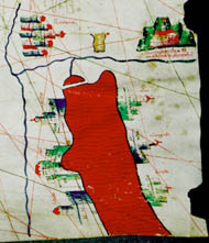
Red Sea detail
1466 Chart![]()
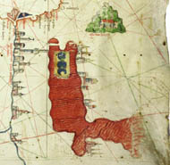
Red Sea detail
1489 Chart
The 1466 Roselli |
 |
 |
 |
 |
 |
In his article Heinrich Winter compares the known Roselli charts with each other. (Winter, 1952).
The Red Sea on the Roselli portolan chart is given a northwesterly and southeasterly orientation; Canepa’s Red Sea is almost straight north and south (the earlier Roselli chart is more accurate). Cities are shown, only along the eastern shore of the Red Sea on the Canepa; on the Roselli cities are placed on both the eastern and western shores.
![]()
Red Sea detail
1466 Chart![]()
Red Sea detail
1489 Chart
The 1466 Roselli |
|
|
|
|
|
©1999-2001 by the Regents of the University of Minnesota, Twin Cities. University Libraries. All rights reserved. Please credit the James Ford Bell Library,
University of Minnesota if you copy or reproduce material from
this page.
URL: http://www.bell.lib.umn.edu/index.html