|
|
1489
|
|
|
 |
![]()
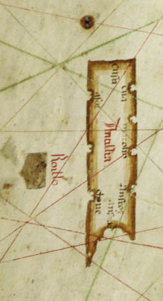
Islands detail
1466 Chart![]()
Islands detail
1489 Chart
The 1466 Roselli |
 |
 |
 |
 |
 |
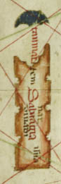
In general the two portolan charts have some intriguing commonalities, especially considering that they were made over a decade apart in different mapmaking centers. Both include what appears to be the island "Antilia" on them.
|
|
1489
|
|
|
|
![]()
Islands detail
1466 Chart![]()
Islands detail
1489 Chart
The 1466 Roselli |
|
|
|
|
|
©1999-2001 by the Regents of the University of Minnesota, Twin Cities. University Libraries. All rights reserved. Please credit the James Ford Bell Library,
University of Minnesota if you copy or reproduce material from
this page.
URL: http://www.bell.lib.umn.edu/index.html