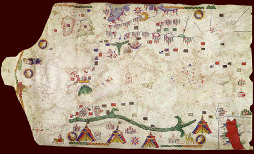
The eastern edge has the holes that would have been used in attaching
it to a wooden roller; on the west, where the skin narrows with
the neck of the animal, there are slits for tying the map.
![]()
The 1466 Roselli |
 |
 |
 |
 |
 |
The 1466 portolan chart covers the south shore of the Baltic in the north to most of the Red Sea in the south, the Black Sea on the east to the Antilia group of islands on the west.
The eastern edge has the holes that would have been used in attaching
it to a wooden roller; on the west, where the skin narrows with
the neck of the animal, there are slits for tying the map.
![]()
The 1466 Roselli |
|
|
|
|
|
©1999-2001 by the Regents of the University of Minnesota, Twin Cities. University Libraries. All rights reserved. Please credit the James Ford Bell Library,
University of Minnesota if you copy or reproduce material from
this page.
URL: http://www.bell.lib.umn.edu/index.html