The text was that of Jacobus Angelus, edited by Bernardus Sylvanus
of Eboli.
 A striking feature of the text is the use of two-color printing.
Most of the text is in black ink but some important names are
printed in red. In order to do this the text had to be passed
through the press twice, once for the printing of each color.
Registration (exact placement of the pages so that the printing
will be in the right place) of the pages for the second inking
had to be carefully done. The twenty eight maps in this edition
are also printed in two-colors, and printing the maps was even
more complicated than printing the text. The maps (without the
text on them) were engraved on wood blocks. For the larger maps,
two wood blocks were often used for a single map. The names of
towns, rivers and mountains were set in type and then inserted
into the wood block, so a map and names on it could both be printed
at the same time, in black ink. The names to be printed in red
were set separately and were printed by a second pass of the maps
pages through the printing press.
A striking feature of the text is the use of two-color printing.
Most of the text is in black ink but some important names are
printed in red. In order to do this the text had to be passed
through the press twice, once for the printing of each color.
Registration (exact placement of the pages so that the printing
will be in the right place) of the pages for the second inking
had to be carefully done. The twenty eight maps in this edition
are also printed in two-colors, and printing the maps was even
more complicated than printing the text. The maps (without the
text on them) were engraved on wood blocks. For the larger maps,
two wood blocks were often used for a single map. The names of
towns, rivers and mountains were set in type and then inserted
into the wood block, so a map and names on it could both be printed
at the same time, in black ink. The names to be printed in red
were set separately and were printed by a second pass of the maps
pages through the printing press.
|
Bernardus Sylvanus wrote that he was incorporating modern discoveries
into Ptolemy’s maps. Apparently he has done this, as
|
|
|
|
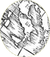 and the "drooping boot" of Italy is fixed as well. |
|
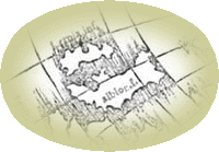
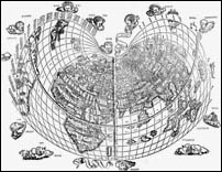
Two world maps are found in this edition. No land connection is
shown between Africa and eastern Asia on either of them. The maps
have nice decorations [click on small maps to see an enlarged
version in a separate window].
|
|
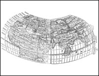 |
Twenty-six of the maps in the 1511 edition are on the familiar
trapezoidal projection.
|
|
One of the world maps is on a "heart-shaped" projection, used
here by Bernardus Sylvanus for the first time in a printed book.
|
 |
![]()
©1999-2001 by the Regents of the University of Minnesota, Twin Cities. University Libraries. All rights reserved. Please credit the James Ford Bell Library,
University of Minnesota if you copy or reproduce material from
this page.
URL: http://bell.lib.umn.edu/index.html