 |
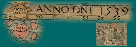
The top, right-hand part if this section carries the date of publication, 1539, with "Polus Articus" to its left and "Insula Magnetum" below the North Pole.
|
This shows that Olaus Magnus was aware of magnetic declination and that the geographic and magnetic North Poles are not the same.
 under the Magnifying Glass |
©1999-2001 by the Regents of the University of Minnesota, Twin Cities. University Libraries. All rights reserved. Please credit the James Ford Bell Library,
University of Minnesota if you copy or reproduce material from
this page. URL: http://bell.lib.umn.edu/index.html