![]() |
||||
![]() |
![]() |
![]() |
![]() |
![]() |
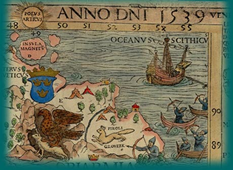
The Olaus Magnus map was a great improvement on earlier maps of Scandinavia. The general geography of Scandinavia is much more accurate. It was the largest and most detailed map of Scandinavia to its time. The blending of Ptolemys map projection with the mariners charts caused some problems, for example, that Scandinavia extends two degrees beyond the North Pole.
In spite of faults, the Carta Marina provides images of the life of the people that are both delightful to look at and rewarding to study. As Robert Karrow put it well, "For Magnus, the map was not just geography but history and ethnography as well" (Karrow 1993, 363).
Under the Magnifying Glass: Olaus' Carta Marina
©1999-2001 by the Regents of the University of Minnesota, Twin Cities. University Libraries. All rights reserved. Please credit the James Ford Bell Library,
University of Minnesota if you copy or reproduce material from
this page.
URL: http://bell.lib.umn.edu/index.html