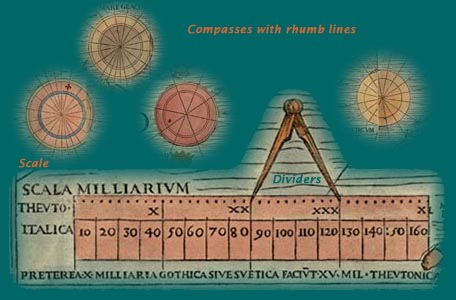
That Olaus intended his map for use by navigators is clear from
its title, and from the other navigational elements on the map:
four large compasses, rhumb lines indicating directions from them,
a pair of dividers, and distance scales. In general the ships
depicted on the map are very well done, with the northern ships
portrayed in their clinker-built style, indicating awareness of
matters relating to ships and the sea.
In the middle of the sixteenth century the Carta Marina had been used by the German geographer Sebastian Munster for
his portrayal of Scandinavia in his large Cosmographia; Beschreibung aller Lender (Cosmography; A Description of All Lands) published for the first
time in 1544. He also used the large wall map in preparing his
edition of Ptolemy’s Geographia published the next year. Abraham Ortelius (Flemish), a famous
sixteenth-century cartographer who is often credited with producing
the first real "atlas" of the world, wrote that he had used the
wall map in creating his map of Scandinavia for his atlas (Theatrum orbis terrarum) published in 1570. From the late sixteenth century onward, however,
no copy of the big wall map was known.