The Red Sea is shown in red, with brown wavy lines and a passageway
marked for the Israelites of the Exodus.
![]()
![]()
![]()
![]()
![]()
![]()
![]()
![]()
![]()
![]()
![]()
![]()
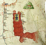
In this portolan chart Canepa has the Red Sea flowing off the bottom of the portolan chart in a southeasterly direction into the Gulf of Aden. This shows more accurate knowledge of the Red Sea, which is an improvement on the earlier Roselli chart (1466) in the James Ford Bell Library.
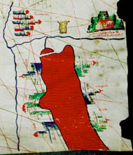
![]() Red Sea detail 1466 Chart
Red Sea detail 1466 Chart
![]()
![]()
![]() Red Sea detail 1489 Chart
Red Sea detail 1489 Chart
The 1489 Canepa |
 |
 |
 |
 |
 |
©1999-2001 by the Regents of the University of Minnesota, Twin Cities. University Libraries. All rights reserved. Please credit the James Ford Bell Library,
University of Minnesota if you copy or reproduce material from
this page.
URL: http://www.bell.lib.umn.edu/index.html